
|
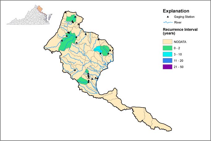
Flood Recurrence Interval: Potomac Basin |
||
|
||
|
||
| Scientists map the
areal extents of floods and assign recurrence intervals using
streamflow data collected by the USGS and the Virginia
Department of Environmental Quality since the late 1800s. Recurrence
intervals express the likelihood that an event, such as a
flood, will occur in any given year. For example, a
100-year-flood has a 1% chance of occurring in any year, and a
25-year flood has a 4% chance of occurring in any year. |
||
| Click here for data in Excel | ||
| Peak Flow Information | ||||||||
| SITE_ID | NAME | DRAINAGE AREA(mi2) |
DATE | TIME | GAGE HT(ft) |
DISCHARGE (cfs) |
RECURRENCE INTERVAL(yrs) |
REMARKS |
| 01636690 | "Piney Run at Route 671 near Lovettsville, Va." | 13.7 | 9/19/2003 | 12:15AM | 3 | -- | -- | -- |
| 01638350 | "South Fork Catoctin Creek at Route 698, near Waterfor" | -- | 9/19/2003 | 5:00AM | 7 | 656 | -- | -- |
| 01638420 | "North Fork Catoctin Creek at Route 681, near Waterfor" | -- | 9/19/2003 | 7:45AM | 4 | -- | -- | -- |
| 01638480 | "Catoctin Creek at Taylorstown, Va." | 89.6 | 9/19/2003 | 8:45AM | 6 | 1060 | <2 | -- |
| 01643590 | "Limestone Branch near Leesburg, Va." | 7.83 | 9/19/2003 | 2:45AM | 2 | 102 | NA | -- |
| 01643700 | "Goose Creek near Middleburg, Va." | 123 | -- | -- | -- | -- | -- | -- |
| 01643805 | "North Fork Goose Creek at Route 729, near Lincoln, Va" | -- | 9/19/2003 | 3:00AM | 8 | 1110 | NA | -- |
| 01643880 | "Beaverdam Creek at Route 734, near Mountville, Va." | -- | 9/19/2003 | 5:45AM | 8 | -- | -- | -- |
| 01644000 | "Goose Creek near Leesburg, Va." | 332 | 9/19/2003 | 3:00AM | 12 | 7980 | 2 | -- |
| 01644280 | "Broad Run near Leesburg, Va." | 76.1 | 9/20/2003 | 4:45AM | 8 | 2190 | NA | -- |
| 01646000 | "Difficult Run near Great Falls, Va." | 57.9 | -- | -- | -- | -- | -- | -- |
| 01652500 | "Fourmile Run at Alexandria, Va." | 14.4-13.8 | 9/18/2003 | 7:40AM | 8 | 2490 | <2 | -- |
| 01653000 | "Cameron Run at Alexandria, Va." | 33.7 | 9/20/2003 | 7:30AM | 6 | 2829 | <2 | -- |
| 01654000 | "Accotink Creek near Annandale, Va." | 23.5 | 9/19/2003 | 12:00AM | 10 | 2490 | <5 | -- |
| 01656000 | "Cedar Run near Catlett, Va." | 93.4 | -- | -- | -- | -- | -- | -- |
| 01658500 | "South Fork Quantico Creek near Independent Hill, Va." | 7.64 | 9/19/2003 | 4:15AM | 6 | 492 | 2 | -- |
| 01659000 | "North Branch Chopawamsic Creek near Joplin, Va." | 5.79 | -- | -- | -- | -- | -- | -- |
| 01659500 | "Middle Branch Chopawamsic Creek near Garrisonville, VA" | 4.51 | -- | -- | -- | -- | -- | -- |
| 01660000 | "South Branch Chopawamsic Creek near Garrisonville, Va" | 2.56 | -- | -- | -- | -- | -- | -- |
| 01660100 | "Chopawamsic Creek at Russell Road near Joplin, Va." | Not Det. | -- | -- | -- | -- | -- | -- |
| 01660400 | "Aquia Creek near Garrisonville, Va." | 34.9 | 9/18/2003 | 11:45AM | 5 | 1030 | <2 | -- |
| 01660500 | "Beaverdam Run near Garrisonville, Va." | 12.7 | 9/18/2003 | 11:45AM | 2 | 88 | -- | -- |
|
USGS--Water Resources of Virginia Contact: GS-W-VArmd_webmaster@usgs.gov URL://va.water.usgs.gov/floodwatch/basins/potomac.htm Last modified: 09/24/03 10:26:15 AM |