
|
Flood Recurrence Interval: Rappahannock-York Basin |
||
|
||
|
||
|
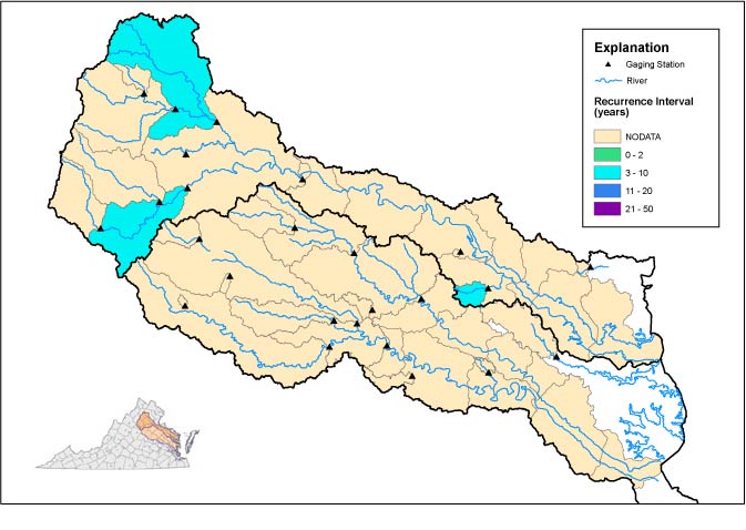
Scientists map the areal extents of
floods and assign recurrence intervals using streamflow data
collected by the USGS and the Virginia Department of Environmental
Quality since the late 1800s. Recurrence intervals express
the likelihood that an event, such as a flood, will occur in any
given year. For example, a 100-year-flood has a 1% chance of
occurring in any year, and a 25-year flood has a 4% chance of
occurring in any year. |
||
| Click here for data in Excel | ||
| Peak Flow Information | ||||||||
| SITE_ID | NAME | DRAINAGE AREA(mi2) |
DATE | TIME | GAGE HT(ft) |
DISCHARGE (cfs) |
RECURRENCE INTERVAL(yrs) |
REMARKS |
| 01661800 | "Bush Mill Stream near Heathsville, Va." | 6.82 | -- | -- | -- | -- | -- | -- |
| 01662800 | "Battle Run near Laurel Mills, Va." | 27.6 | -- | -- | -- | -- | -- | -- |
| 01663500 | "Hazel River at Rixeyville, Va." | 287 | 9/19/2003 | 1:30AM | 19 | -- | -- | -- |
| 01664000 | "Rappahannock River at Remington, Va." | 620 | 9/20/2003 | 12:45AM | 18 | 15400 | 5 | -- |
| 01665050 | "Pony Mountain Branch near Culpeper, Va." | 0.3 | -- | -- | -- | -- | -- | -- |
| 01665500 | "Rapidan River near Ruckersville, Va." | 114 | -- | -- | -- | -- | -- | -- |
| 01666500 | "Robinson River near Locust Dale, Va." | 179 | -- | -- | -- | -- | -- | -- |
| 01667500 | "Rapidan River near Culpeper, Va." | 472 | 9/19/2003 | 9:00AM | 19 | 20700 | 7 | -- |
| 01668000 | "Rappahannock River near Fredericksburg, Va." | "1,596" | -- | -- | -- | -- | -- | -- |
| 01668300 | "Farmers Hall Creek near Champlain, Va." | 2.18 | -- | -- | -- | -- | -- | -- |
| 01669000 | "Piscataway Creek near Tappahannock, Va." | 28 | 9/19/2003 | 12:00AM | 8 | 879 | 10 | -- |
| 01669520 | "Dragon Swamp at Mascot, Va." | 108 | -- | -- | -- | -- | -- | -- |
| 01670180 | "Pamunkey Creek at Lahore, Va." | 40.5 | -- | -- | -- | -- | -- | -- |
| 01670300 | "Contrary Creek near Mineral, Va." | 5.53 | -- | -- | -- | -- | -- | -- |
| 01671020 | "North Anna River at Hart Corner near Doswell, Va." | 463 | -- | -- | -- | -- | -- | -- |
| 01671100 | "Little River near Doswell, Va." | 107 | -- | -- | -- | -- | -- | -- |
| 01671650 | "Waldrop Creek near Louisa, Va." | 2.85 | -- | -- | -- | -- | -- | -- |
| 01672500 | "South Anna River near Ashland, Va." | 394 | 9/19/2003 | 2:30AM | 16 | -- | -- | -- |
| 01673000 | "Pamunkey River near Hanover, Va." | "1,081" | -- | -- | -- | -- | -- | -- |
| 01673550 | "Totopotomoy Creek near Studley, Va." | 26.2 | -- | -- | -- | -- | -- | -- |
| 01673638 | "Cohoke Mill Creek near Lester Manor, Va." | 9.07 | 9/19/2003 | 12:15AM | 9 | 847 | -- | -- |
| 01673800 | "Po River near Spotsylvania, Va." | 77.4 | -- | -- | -- | -- | -- | -- |
| 01674000 | "Mattaponi River near Bowling Green, Va." | 257 | -- | -- | -- | -- | -- | -- |
| 01674200 | "Reedy Creek near Dawn, Va." | 16.8 | -- | -- | -- | -- | -- | -- |
| 01674500 | "Mattaponi River near Beulahville, Va." | 601 | -- | -- | -- | -- | -- | -- |
|
USGS--Water Resources of Virginia Contact: GS-W-VArmd_webmaster@usgs.gov URL://va.water.usgs.gov/floodwatch/basins/rappahannockyork.htm Last modified: 09/24/03 10:27:29 AM |