

|
|
|
|
|
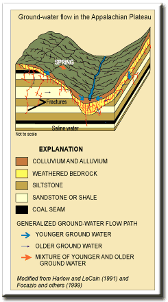
The Appalachian
Plateaus province encompasses approximately 1,600 mi2
and is characterized by a well-dissected mountainous landscape with
dendritic drainage Ground-Water Flow Ground-water flow occurs in (1) the regolith (unconsolidated alluvium, colluvium, and saprolite) and (2) along fractures and joints in the bedrock. Recharge to the fractured rock aquifers is somewhat limited by the highly dissected, steep terrain and relatively impermeable bedrock. Ground water moves steplike along the more permeable vertical fractures and sub-horizontal coal and sandstone beds (Harlow and LeCain, 1991; Trapp and Horn, 1997). Generally, apparent ground-water ages can be relatively old; however, downward movement of water along the vertical fractures can be rapid and enhanced by pumpage. |
|
References Focazio, M.J., Plummer, L.N., Böhlke, J.K., Busenberg, Eurybiades, Bachman, L.J., and Powars, D.S., 1998, Preliminary estimates of residence times and apparent ages of ground water in the Chesapeake Bay Watershed, and water-quality data from a survey of springs: U.S. Geological Survey Water-Resources Investigations Report 97-4225, 75 p. Harlow, G.E., Jr., and LeCain, G.D., 1991, Hydraulic characteristics of, and ground-water flow in, coal-bearing rocks of southwestern Virginia: U.S. Geological Survey Water-Supply Paper 2388, 36 p Powell, J.D., and Larson, J.D., 1985, Relation between ground-water quality and mineralogy in the coal-producing Norton Formation of Buchanan County, Virginia: U.S. Geological Survey Water-Supply Paper 2274, 30 p. Trapp, Henry, Jr., and Horn, M.A., 1997, Ground Water Atlas of the United States: Delaware, Maryland, New Jersey, North Carolina, Pennsylvania, Virginia, West Virginia: U.S. Geological Survey Hydrologic Atlas HA 730-L, p. . Wyrick, G.G., and Borchers, J.W., 1981, Hydrologic effects of stress-relief fracturing in an Appalachian valley: U.S. Geological Survey Water-Supply Paper 2177, 51 p.
|
|
|
|
|

|

|

|
|
|
| Last Updated on 2/4/2002 By David L. Nelms |
Contact: GS-W-VArmd_webmaster@usgs.gov
U.S. Department of Interior,
U.S. Geological Survey
Privacy Statement
Disclaimer
Accessibility
URL http://va.water.usgs.gov/va123/4strat-AP.html
Last update: 09/15/04 12:49
 formed on almost flat-lying to gently folded Paleozoic sedimentary rocks
(Trapp and Horn, 1997).
formed on almost flat-lying to gently folded Paleozoic sedimentary rocks
(Trapp and Horn, 1997).