

|
|
|
|
The Piedmont Physiographic Province encompasses
approximately 16,300 mi2 along the eastern part of
the study area and consists of a gently rolling plain underlain by
polydeformed and metamorphosed Proterozoic and Paleozoic rocks (Fisher,
1970, p. 295). A thick mantle
of soil and weathered rock (saprolite, regolith, or residuum) that overlies the fractured crystalline bedrock
is a characteristic feature of the province (Meyer and others, 1965; 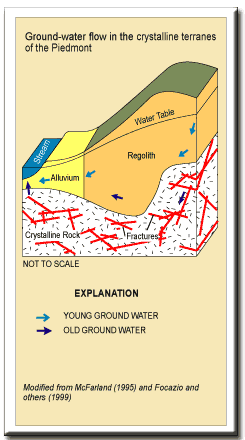 Conley,
1985, p. 1; Swain and others, 1991, p. 12). Generally, regolith developed on the crystalline rocks is thick under
the hilltops and thin to absent in the stream valleys (Richardson, 1982, p.
6; Pavich and others, 1989, p. 43). Elevations
range from about 200 ft above sea level along the eastern border to 1,000 ft
above sea level along the western border of the province. Down-faulted Mesozoic sedimentary basins, which encompass
approximately 1,340 mi2, are located within the
Piedmont Physiographic Province. These
basins are underlain by shale, siltstone, mudstone, sandstone, and basalt and are
characterized by generally lower relief than the surrounding Piedmont (Hack,
1989, p. 461). Thin soils and
shallow weathering profiles are characteristic features of the rocks in the
Mesozoic Basins (Froelich, 1985; Conley, 1985, p. 2). Hack (1982, p. 3) noted that the Piedmont Physiographic Province of
Virginia consists of the Foothill zone on the west, the Piedmont Lowlands on
the e Conley,
1985, p. 1; Swain and others, 1991, p. 12). Generally, regolith developed on the crystalline rocks is thick under
the hilltops and thin to absent in the stream valleys (Richardson, 1982, p.
6; Pavich and others, 1989, p. 43). Elevations
range from about 200 ft above sea level along the eastern border to 1,000 ft
above sea level along the western border of the province. Down-faulted Mesozoic sedimentary basins, which encompass
approximately 1,340 mi2, are located within the
Piedmont Physiographic Province. These
basins are underlain by shale, siltstone, mudstone, sandstone, and basalt and are
characterized by generally lower relief than the surrounding Piedmont (Hack,
1989, p. 461). Thin soils and
shallow weathering profiles are characteristic features of the rocks in the
Mesozoic Basins (Froelich, 1985; Conley, 1985, p. 2). Hack (1982, p. 3) noted that the Piedmont Physiographic Province of
Virginia consists of the Foothill zone on the west, the Piedmont Lowlands on
the e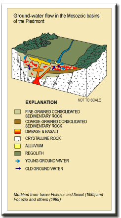 ast, and the Northeastern Highlands
on the north. The Foothill zone also encompasses the southeastern part of the Blue
Ridge Physiographic Province. The
part of the Foothill zone north of the Roanoke River is underlain by
resistant volcanic and metamorphic rocks that form chains of isolated hills
and ridges. The part of the
Foothill zone south of the Roanoke River is underlain by resistant rocks of
the Smith River allochthon that form an upland (Hack, 1982, p. 24). The Piedmont Lowlands are underlain by feldspathic gneiss and schist
intruded by granitic plutons with lesser amounts of metasedimentary and
metavolcanic rocks that form low ridges or hills and ravines. ast, and the Northeastern Highlands
on the north. The Foothill zone also encompasses the southeastern part of the Blue
Ridge Physiographic Province. The
part of the Foothill zone north of the Roanoke River is underlain by
resistant volcanic and metamorphic rocks that form chains of isolated hills
and ridges. The part of the
Foothill zone south of the Roanoke River is underlain by resistant rocks of
the Smith River allochthon that form an upland (Hack, 1982, p. 24). The Piedmont Lowlands are underlain by feldspathic gneiss and schist
intruded by granitic plutons with lesser amounts of metasedimentary and
metavolcanic rocks that form low ridges or hills and ravines.Description from Nelms and others (1997) Ground-Water Flow Ground-water flow in the crystalline terranes occurs (1) in the regolith (predominantly saprolite) and (2) along fractures and joints in the bedrock. Most of the ground-water storage in the crystalline terranes is in the saprolite, which overlies the crystalline bedrock. Ground-water flow in the Mesozoic Basins predominantly occurs along fractures, joints, and bedding plane partings in the bedrock. Ground-water storage in the rocks of the Mesozoic Basins is predominantly in the fractures, joints, and bedding plane partings in the bedrock because of the thin mantle of saprolite. Apparent ground-water ages can be relatively young because flow velocities and gradients can be high in the vicinity of pumping wells and ground-water storage is limited in the fractured rock aquifers in the Piedmont. |
|
References Conley, J.F., 1985, Geology of the southwestern Virginia Piedmont: Virginia Division of Mineral Resources Publication 59, 33 p. Focazio, M.J., Plummer, L.N., B�hlke, J.K., Busenberg, Eurybiades, Bachman, L.J., and Powars, D.S., 1998, Preliminary estimates of residence times and apparent ages of ground water in the Chesapeake Bay Watershed, and water-quality data from a survey of springs: U.S. Geological Survey Water-Resources Investigations Report 97-4225, 75 p. Froelich, A.J., 1985, Map and geotechnical properties of surface materials of the Culpeper Basin and vicinity, Virginia and Maryland: U.S. Geological Survey Miscellaneous Investigations Series Map I- 1313-E, 1 sheet, scale 1:125,000. Fisher, G.W., 1970, The Piedmont: Introduction, in Fisher, G.W., Pettijohn, F.J., Reed, J.C., Jr., and Weaver, K.N., eds., Studies of Appalachian geology: Central and southern: New York, Wiley- Interscience, p. 295-298. Hack, J.T., 1982, Physiographic divisions and differential uplift of the Piedmont and Blue Ridge: U.S. Geological Survey Professional Paper 1265, 49 p. _____1989, Geomorphology of the Appalachian Highlands, in Hatcher, R.D., Jr., Thomas, W.A., and Viele, G.W., eds., The Appalachian-Ouachita orogen in the United States, v. F-2 of The geology of North America: Boulder, Colo., Geological Society of America, p. 459-470. Meyer, Gerald, Wilmoth, B.M., and LeGrand, H.E., 1965, Availability of ground water in the Appalachian region, in Schneider, W.J., and others, Water resources of the Appalachian region, Pennsylvania to Alabama: U.S. geological Survey Hydrologic Investigations Atlas HA-198, 11 sheets, scale 1:2,500,000. Nelms, D.L., Harlow, G.E., Jr., and Hayes, D.C., 1997, Base-flow characteristics of streams in the Valley and Ridge, the Blue Ridge, and the Piedmont Physiographic Provinces of Virginia: U.S. Geological Survey Water-Supply Paper 2457, 48 p. Pavich, M.J., Leo, G.W., Obermeier, S.F., and Estabrook, J.R., 1989, Investigations of the characteristics, origin, and residence time of the upland residual mantle of the Piedmont of Fairfax County, Virginia: U.S. Geological Survey Professional Paper 1352, 58 p. Richardson, C.A., 1982, Ground water in the Piedmont Upland of Central Maryland: U.S. Geological Survey Water-Supply Paper 2077, 42 p. Swain, L.A., Hollyday, E.F., Daniel, C.C., III, and Zapecza, O.S., 1991, Plan of study for the Regional Aquifer-System Analysis of the Appalachian Valley and Ridge, Piedmont, and Blue Ridge Physiographic Provinces of the Eastern and Southeastern United States, with a description of study- area geology and geohydrology: U.S. Geological Survey Water-Resources Investigations Report 91- 4066, 44 p. |
|
|
|
|

|

|

|
|
|
| Last Updated on 2/4/2002 By David L. Nelms |
Contact: GS-W-VArmd_webmaster@usgs.gov
U.S. Department of Interior,
U.S. Geological Survey
Privacy Statement
Disclaimer
Accessibility
URL http://va.water.usgs.gov/va123/4strat-PD.html
Last update: 09/15/04 12:57