

|
|
|
|
The Valley and Ridge Physiographic Province
encompasses approximately 10,600 mi2
along the western part of the study area and consists of a belt of
northeast-southwest trending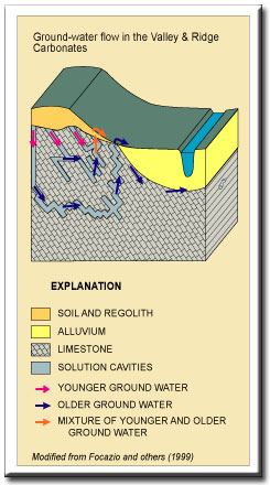 ridges and valleys formed by the differential
erosion of a thick sequence of folded and faulted Paleozoic sedimentary
rocks (Pettijohn, 1970, p. 1). Elevations
range from about 380 ft above sea level where the Shenandoah River flows out
of Virginia into Maryland to 4,604 ft above sea level in southwestern
Virginia (Butts, 1940, p. 14). North
of Roanoke, the province is part of the central Appalachians and is
separated into two subdivisions: (1)
a southeastern valley area, commonly referred to as the Great Valley,
underlain by Cambrian-age to Ordovician-age carbonate rocks and shales
characterized by broad valleys with interspersed ridges or hills; and (2) a
northwestern ridge area underlain by Silurian-age to Pennsylvanian- age
sandstones and shales characterized by high ridges with interspersed narrow
valleys (Hack, 1989, p. 463). Another
feature of the province north of Roanoke is the presence of a thick mantle
of residuum, talus, and alluvial deposits that overlie the Cambrian
carbonate rocks on the eastern slope of the valley at the foot of the Blue
Ridge (King, 1950, p. 54; Leonard, 1962;
ridges and valleys formed by the differential
erosion of a thick sequence of folded and faulted Paleozoic sedimentary
rocks (Pettijohn, 1970, p. 1). Elevations
range from about 380 ft above sea level where the Shenandoah River flows out
of Virginia into Maryland to 4,604 ft above sea level in southwestern
Virginia (Butts, 1940, p. 14). North
of Roanoke, the province is part of the central Appalachians and is
separated into two subdivisions: (1)
a southeastern valley area, commonly referred to as the Great Valley,
underlain by Cambrian-age to Ordovician-age carbonate rocks and shales
characterized by broad valleys with interspersed ridges or hills; and (2) a
northwestern ridge area underlain by Silurian-age to Pennsylvanian- age
sandstones and shales characterized by high ridges with interspersed narrow
valleys (Hack, 1989, p. 463). Another
feature of the province north of Roanoke is the presence of a thick mantle
of residuum, talus, and alluvial deposits that overlie the Cambrian
carbonate rocks on the eastern slope of the valley at the foot of the Blue
Ridge (King, 1950, p. 54; Leonard, 1962; 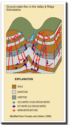 Hack, 1965, p. 48; Hack, 1989, p. 464).
This belt of residuum, commonly referred to as the “Western Toe”
of the Blue Ridge, can exceed 600 ft in thickness (T.M. Gathright, II,
Virginia Division of Mineral Resources, oral commun., 1994). South of Roanoke, the province is part of the southern Appalachians
and is characterized by ridges and narrow valleys, and the predominant style
of deformation within the province changes from folding to thrust faulting
(Hack, 1989, p. 463). Hack, 1965, p. 48; Hack, 1989, p. 464).
This belt of residuum, commonly referred to as the “Western Toe”
of the Blue Ridge, can exceed 600 ft in thickness (T.M. Gathright, II,
Virginia Division of Mineral Resources, oral commun., 1994). South of Roanoke, the province is part of the southern Appalachians
and is characterized by ridges and narrow valleys, and the predominant style
of deformation within the province changes from folding to thrust faulting
(Hack, 1989, p. 463).
Ground-Water Flow Ground-water flow in the carbonate rocks of the Valley & Ridge occurs (1) in the regolith (alluvium, colluvium, and residuum), (2) along fractures, joints, and bedding plane partings in the bedrock, and (3) in solution channels and cavities (caves) formed by the dissolution of carbonate minerals. Ground-water storage in the carbonate rocks can be in the regolith and in the solution channels and cavities in the bedrock. Ground-water flow in the siliciclastic rocks (sandstone, shale, and siltstone) of the Valley & Ridge occurs (1) in the regolith (primarily alluvium and colluvium), and (2) along fractures, joints, and bedding plane partings in the bedrock. Hobba (1972) estimated that circulation depths of ground water in the thermal spring areas of western Virginia are over 1,500 feet. Ground-water storage in the siliciclastic rocks can be in the regolith and in the fractures, joints, and bedding plane partings. Apparent ground-water ages can be relatively young because flow velocities and gradients are high, especially in the solution channels and cavities in the carbonate aquifers, and ground-water storage is limited in the fractured rock aquifers in the Valley & Ridge. |
|
References Butts, Charles, 1940, Geology of the Appalachian Valley in Virginia: Virginia Geological Survey Bulletin 52, 568 p. Focazio, M.J., Plummer, L.N., Böhlke, J.K., Busenberg, Eurybiades, Bachman, L.J., and Powars, D.S., 1998, Preliminary estimates of residence times and apparent ages of ground water in the Chesapeake Bay Watershed, and water-quality data from a survey of springs: U.S. Geological Survey Water-Resources Investigations Report 97-4225, 75 p. Hack, J.T., 1965, Geomorphology of the Shenandoah Valley Virginia and West Virginia and origin of the residual ore deposits: U.S. Geological Survey Professional Paper 484, 84 p. _____1989, Geomorphology of the Appalachian Highlands, in Hatcher, R.D., Jr., Thomas, W.A., and Viele, G.W., eds., The Appalachian-Ouachita orogen in the United States, v. F-2 of The geology of North America: Boulder, Colo., Geological Society of America, p. 459-470. Hobba, W., 1972, Geomorphology of the Shenandoah Valley Virginia and West Virginia and origin of the residual ore deposits: U.S. Geological Survey Professional Paper 484, 84 p. King, P.B., 1950, Geology of the Elkton area, Virginia: U.S. Geological Survey Professional Paper 230, 82 p. Leonard, R.B., 1962, Ground-water geology along the northwest foot of the Blue Ridge between Arnold Valley and Elkton, Virginia: Blacksburg, Virginia Polytechnic Institute and State University, Ph.D. dissertation. Nelms, D.L., Harlow, G.E., Jr., and Hayes, D.C., 1997, Base-flow characteristics of streams in the Valley and Ridge, the Blue Ridge, and the Piedmont Physiographic Provinces of Virginia: U.S. Geological Survey Water-Supply Paper 2457, 48 p. Pettijohn, F.J., 1970, The Valley and Ridge—Stratigraphy and sedimentation, Introduction, in Fisher, G.W., Pettijohn, F.J., Reed, J.C., Jr., and Weaver, K.N., eds., Studies of Appalachian geology: Central and southern: New York, Wiley-Interscience, p. 1-3. |
|
|
|
|

|

|

|
|
|
| Last Updated on 2/4/2002 By David L. Nelms |
Contact: GS-W-VArmd_webmaster@usgs.gov
U.S. Department of Interior,
U.S. Geological Survey
Privacy Statement
Disclaimer
Accessibility
URL http://va.water.usgs.gov/va123/4strat-VR.html
Last update: 09/15/04 12:58