USGS visual identity banner


National Water Monitoring Day
"Snapshot" of the James River Watershed

Year of Clean Water Logo
link to sample data James River near Richmond, VA James River and Kanawha Canal near Richmond, VA James River near Cartersville, VA James River near Scottsville, VA James River at Bent Creek, VA James River at Holcomb Rock, VA James River at Buchanan, VA James River at Lick Run, VA Jackson River below Dunlap Creek Jackson River below Gathright Dam Jackson River at Bacova, VA Monitoring Sites map bar chart thumbnail
Monitoring Sites by Watershed


James River Monitoring Data and maps

Activities in Virginia

Photographs from National Water Monitoring Day on the James River at Tredegar Iron Works.

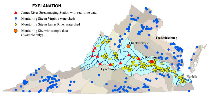
Students and citizens collected and analyzed water samples from more than 6000 sites in Virginia. Click here for water-quality data from 200 samples from the James River Watershed. 


VA DCR logoVA DEQ logoIzaak Walton League logoJames River Association logoAlliance for Chesapeake Bay logoVirginia Water Monitoring Council logo Virginia Environmental Endowment logo


USGS--Water Resources of Virginia                                                

Contact: GS-W-VArmd_webmaster@usgs.gov
U.S. Department of Interior, U.S. Geological Survey
Privacy Statement
Disclaimer

URL://va.water.usgs.gov/wqday/vawqd.html      Last modified: 01/17/03 09:44:27 AM