USGS - science for a changing world

Virginia Water Science Center

Clarke County Web site.

Search this site:

DATA CENTER

USGS IN YOUR STATE

USGS Water Science Centers are located in each state.

There is a USGS Water Science Center office in each State. Washington Oregon California Idaho Nevada Montana Wyoming Utah Colorado Arizona New Mexico North Dakota South Dakota Nebraska Kansas Oklahoma Texas Minnesota Iowa Missouri Arkansas Louisiana Wisconsin Illinois Mississippi Michigan Indiana Ohio Kentucky Tennessee Alabama Pennsylvania West Virginia Georgia Florida Caribbean Alaska Hawaii New York Vermont New Hampshire Maine Massachusettes South Carolina North Carolina Rhode Island Virginia Connecticut New Jersey Maryland-Delaware-D.C.

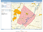
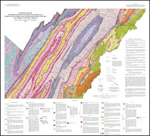
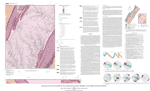
Geographic Information System (GIS) Data for Clarke County, Virginia

Geographic information system (GIS) data consists of map layers that are being used to evaluate the relations between the hydrogeology, geologic structures, and topography


 Clarke County Web-based Map Viewer Clarke County Web-Based Map Viewer (Opens page in new window. )-- The County's GIS map layers are available online through interactive map viewer.  The map layers available are: 
       
Public Major Roads Floodplain-100Yr Zoning
Points of Interest Roads Buildings Aerial Photos
Springs County Boundary Topography Surrounding Counties
Sinkholes Streams Parcels  
Gas Lines Open Water Towns  
Power Lines Floodplain-10Yr Soils  

 
VDMR GIS data Virginia Division of Mineral Resources (VDMR) (Opens page in new window. ) -- VDMR has digital representations and printed geologic maps available online at the Virginia Department of Mines, Minerals and Energy (DMME) Web Store.  


USGS GIS data U.S. Geological Survey (USGS) (Opens page in new window. ) -- USGS has digital representations of the geology, topography, and hydrology of the County.


Current Water Conditions for Clarke Co.

Shaded relief map of Clarke County, Va.The USGS provides current ("real-time") stream stage and streamflow, water-quality, and ground-water levels for 4 sites in Clarke County, Va.

Current Water Conditions for the Shenandoah Valley

Shaded relief map of the Shenandoah Valley of Virginia and West VirginiaThe USGS and Virginia Department of Environmental Quality provide current ("real-time") stream stage and streamflow, water-quality, and ground-water levels for 35 sites in the Shenandoah Valley of Virginia and West Virginia.

USGS Home Water Resources Biology Geography Geology Geospatial

Accessibility FOIA Privacy Policies and Notices

Take Pride in America logo FirstGov logo U.S. Department of the Interior | U.S. Geological Survey
URL: http://va.water.usgs.gov/clarke/gis.htm
Page Contact Information: webmaster-va@usgs.gov
Page Last Modified: 28-Feb-2008 14:00:00 EST