Virginia Water Science Center
Project Information Title: Number: Location: Cooperating Agencies: Project Chief: Period of Project: Publications:
USGS IN YOUR STATEUSGS Water Science Centers are located in each state. 
|
Peak-Flow Characteristics of Virginia StreamsNeeds Economic growth, and the development, management, and protection of Virginias natural resources require anticipating peak stream flows and changes in peak stream flows over time. Extensive hydraulic analysis and smart design are needed to limit the environmental impacts of buildings, pavements, highways, and bridges. Effective design and placement of structures built near streams and on flood plains requires an understanding of peak discharges and basin characteristics of streams. Knowledge of the magnitude and frequency of peak discharge is needed to construct highway bridges and culverts, locate transportation infrastructure, and design flood-control structures. Knowledge of basin characteristics is needed to use peak flow characteristics at ungaged locations. Scientific Investigations These needs are addressed through cooperative study and a series of scientific investigations.
A Network of Peak-Flow Gaging Stations Since 1949, the USGS, in cooperation with the Virginia Department of Transportation (VDOT), has maintained a network of partial-record peak-discharge gaging stations. These, combined with other continuous-record gaging stations, provide annual peak-discharge data at more than 550 gaging station locations throughout Virginia. Most of these gages have 10 years or more of peak-discharge data. Data from these gages may be found here: https://nwis.waterdata.usgs.gov/usa/nwis/peak The Benefits of Quality Data and Science Quality peak-flow data, combined with continued collaborative scientific investigation, provide uniquely useful application oriented information and analyses vital to understanding, anticipating, and better managing Virginias stream flows, basins, and ecosystems. 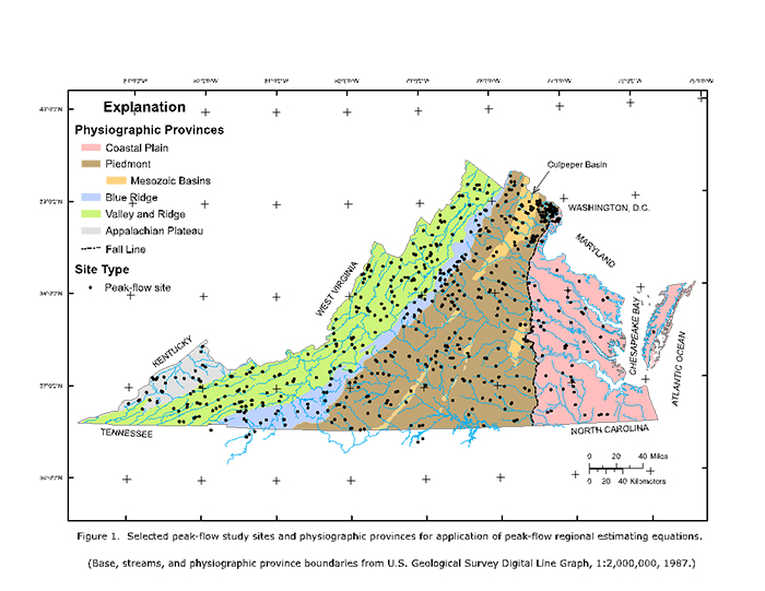 |

![]() U.S. Department of the Interior | U.S. Geological Survey
U.S. Department of the Interior | U.S. Geological Survey
URL: https://va.water.usgs.gov/projects/peak_flow.htm
Page Contact Information: webmaster-va@usgs.gov
Page Last
Modified: Tuesday, 11-Apr-2017 14:34:53 EDT
