|

|
|
Virginia Beach Shallow Groundwater Study

|
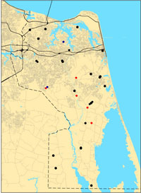
Monitoring Wells
|
|
|
|
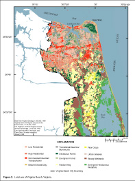
Land
Use
Groundwater Pumping Study
|
The purpose of the Virginia Beach shallow aquifer study is to better
understand the distribution of fresh groundwater, its susceptibility to
contamination, and its sustainability as a long-term water supply.
Virginia Beach Water Resources
Virginia Beach is a growing city in southeastern Virginia with a limited
supply of fresh water. Most of the city�s drinking water, up to 45 million
gallons per day, comes from Lake Gaston. The Lake Gaston pipeline
supplies water for the northern half of Virginia Beach, but the southern rural
boroughs rely solely on groundwater
(Johnson,
1999).
Ongoing Studies
Shallow Groundwater Use - Northern Virginia Beach
The city of Virginia Beach
has an interest in preserving the limited supply of water in the shallow
aquifers for drinking, irrigation, lawn watering, heat pumps, and
potentially for desalination. In the Northern part of the city, private wells primarily provide water for
irrigation, car washing, pool filling, and other seasonal uses. Supplies
of groundwater are limited, however, because of high concentrations of
iron, manganese, chloride and (or) sulfide ions in some areas. At depths
greater than approximately 150 to 200 ft, the water is generally too saline
to drink or use for irrigation.
A study of water use in northern Virginia Beach is ongoing. Seasonal water use
will be estimated by applying water use methods developed by the USGS.
Aquifer Simulation
The USGS has developed a model of groundwater flow and groundwater salinity in
the shallow aquifers of the
southern watersheds of Virginia Beach
(Smith, 2003). The model can be used to
simulate a wide variety of scenarios involving groundwater use. For example, the slow but steady movement
of chloride concentrations toward a hypothetical well field pumping from the York-Eastover aquifer has
been simulated (Smith, 2005), as well as drawdown around hypothetical open-pit mines in the Columbia aquifer.
A USGS Scientific Investigations Report on the results of the groundwater flow simulations for the shallow aquifers was published
in the summer of 2005.
Reports: Smith, 2003,
Smith, 2005
Geologic Characterization
The
hydrogeologic framework of the shallow aquifer
system at Virginia Beach was revised to provide a better understanding of the distribution of fresh
groundwater, its potential use, and its susceptibility to contamination.
The revised conceptual framework is based primarily on analyses of
continuous cores and downhole geophysical logs collected at 7 sites to
depths of approximately 200 ft.
Reports:
Smith and Harlow, 2002
Ground-Water Monitoring
A water-level and water-quality network has been established in the
city and includes a growing number of continuous wells that measure
groundwater levels every 15 minutes.
View Map
of Wells
In 2004, the USGS and the Virginia Department of Public
Utilities expanded the observation-well network and simulated ground-water
pumping from the shallow aquifers in the Transition Area. In 2005 and 2006, more continuous-record wells including
"real-time" water-level monitors were added to the network. In
2007 new probes will be added to two wells for measuring temperature and salinity.
|
|
Publications:
1.
Virginia
Beach Shallow Ground-Water Study USGS Fact Sheet (Johnson,
1999)
2. Conceptual Hydrogeologic Framework of the
Shallow Aquifer System at Virginia Beach, Virginia (Smith &
Harlow, 2001)
WRIR
01-4262
3. Ground-Water Flow and
Saline Water in the Shallow Aquifer System of the Southern
Watersheds of Virginia Beach, Virginia (Smith, 2003)
WRIR
03-4258
4. Simulated Changes in Water
Levels Caused by Potential Changes in Pumping from Shallow
Aquifers of Virginia Beach, Virginia (Smith, 2005)
SIR
2005-5067
5. Outdoor Water Use and Water Conservation Opportunities in
Virginia Beach, Virginia (Eggleston, 2010)
FS 2010-3007
6. Assessing the magnitude and timing of anthropogenic warming
of a shallow aquifer: example from Virginia Beach, USA (Eggleston and McCoy, 2014)
Hydrogeology Journal
|
|