Virginia Water Science Center
|
|
|
||
|
Project Information Number Location USGS Collaborators Mark R. Bennett Kenneth E. Hyer Jennifer L. Krstolic W. Scott Gain Greg C. Johnson Brett Ostby David A. Kirkland William H. Orem
Project Contact
PDF of ERLT ERIC Powerpoint
Presentation
PDF of ERIC
CPCRI Science Team Data Review 2010 Dungannon intensive water-quality monitoring station Looneys Gap (Horton Ford) intensive water-quality monitoring station Clinch Powell Clean Rivers Initiative Members |
Eastern Region Initiative on the Clinch (ERIC)
|
2009-2011 Field Data Collection Activities and Results
Problem: The Clinch and Powell Rivers flowing from southwestern Virginia through parts of East Tennessee (fig. 1) support unique and nationally significant endemic and endangered populations of fresh-water mussels and other aquatic fauna. Surveys of mussel and fish community structure over past decades have shown a pattern of decline throughout the Powell River and on parts of the upper Clinch that have suggested a connection to changing land-use practices in these river basins—in particular to possible episodic or chronic effects of coal mining on water quality and hydrology. Localized losses in species richness and declines in population health, however, have not been linked exclusively to any one cause in these basins and may in fact be the result of a combination of stresses including coal mining, other energy extraction practices, agricultural practices, urban development, and increases in hydrologic extremes.
Many mussel species are intolerant to even small changes in water quality and hydrology and many are endemic to small and isolated stream reaches that are particularly susceptible to hydrologic alteration. Given the inherent difficulties in observing and characterizing the ecology of these sensitive aquatic fauna in hydrologically complex and multiply-disturbed environments, a comprehensive study of stress and response related to changing land use, increasing energy extraction practices or climate change is beyond the usual reach and capability of any one organization working in the area. To forecast ecosystem change and to manage that change in relation to spatially and temporally diffuse stresses will require a broad interdisciplinary and multi-partner study based on a shared foundation of reliable and consistent hydrologic, biological, geological, and geographic information.
Relevance: The ERIC project will support the Clinch-Powell Clean Rivers Initiative (CPCRI), a new collaborative effort of numerous of non-profit, state, and federal agencies working in Virginia and Tennessee has developed a draft science plan that begins to identify the most pressing science questions to be addressed on a broad scale.
The ERIC project will supply a platform of basic hydrologic, biological, geological, and geographic understanding that the USGS is uniquely situated to provide. By working in support of the CPCRI effort we have an opportunity to expand on-going USGS efforts in the watershed and contribute to a larger effort of significant regional importance.
Objectives: The primary science goal of this proposal is to provide a basic foundation of hydrologic, biological, and geographic data collection, summary, and evaluation on the Clinch River to support process-level studies of ecosystem response to stress as the first step in understanding and forecasting ecosystem change in response to changes in land use, energy extraction practices and climate.
Scope of Activities: The activities included in this proposal will help USGS integrate and expand on-going efforts while providing core information to support work of other agencies. The USGS is well positioned to support the larger CPCRI effort by providing a core of hydrologic, biological, geochemical, and geographic information upon which additional studies and can be built. The water science centers in TN and VA are currently monitoring water quality and geomorphology within the basin, while the Missouri BRD and VA BRD Coop Units are doing toxicology studies and population studies respectively.
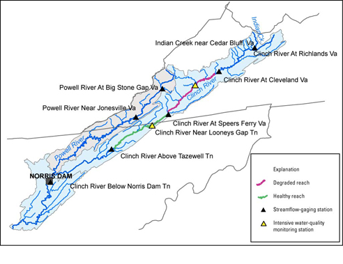
The geographic and temporal scope of this study is necessarily limited by available funding. Though we have a general interest in the status of aquatic communities over the entire length of the Clinch River including the upper embayments of the Lake Norris in Tennessee, the primary focus of this effort will concentrate on mussel community health, water and sediment quality, habitat characterization and land-use change in an 80-mile reach (and surrounding watershed) at the center of the Clinch River basin from near Cleveland, VA, crossing the Virginia-Tennessee State line, to near Sneedville, TN.
Approach: Discharge, water-quality, sediment quality, and juvenile mussel survival will be evaluated over a period of three years at two primary monitoring sites and at about 8 other point locations along this reach (figure 1; table 1). The upstream water-quality monitoring site at Dungannon, VA falls in the center of a 20-30 mile reach immediately below St. Paul, VA noted historically for declines in species diversity and little or no mussel propagation (despite apparently ideal habitat and hydrology). The downstream site at Looney’s Gap, TN falls at the upper end of a 40-mile reach noted for mussel species richness and population health. Sampling and characterization along this reach of the Clinch River provides a clear point of comparison between degraded mussel populations upstream and healthier populations downstream. If the health of mussel populations in the Clinch River is related to an ongoing problem with water or sediment, paired sampling and habitat assessments at these two sites and along the reach ought to provide the best opportunity to document statistically significant environmental stressors. Analyses of land-use change and water quality should help to identify the potential sources of these stressors. Studies of juvenile survival ought to help demonstrate the link between environmental stress and ongoing degradation.
Note: PDF Reader available at
get.adobe.com/reader/
| AccessibilityFOIAPrivacyPolicies and Notices | |
 |
|
