|
Components of the Virginia Coastal Plain Ground-Water
GIS
|
|
Virginia
Coastal Plain GIS Project

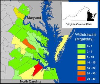 Ground-Water Withdrawals by County
for the Virginia
Coastal Plain |
Problem
The Atlantic Coastal Plain aquifer system is a heavily-used water resource in Virginia.
Daily ground-water withdrawals of more than 150 million gallons are an
important part of the region�s water supply. Ground water is the source of
drinking water for over 900,000 people in the Virginia Coastal Plain, and it is
also an important component of withdrawals for industrial, agricultural, and
commercial uses.
The USGS, with cooperation from the Virginia Department
of Environmental Quality and the Hampton Roads Planning District Commission,
is involved in several related and on-going regional projects directed at
better characterization of this important resource. The large amount of
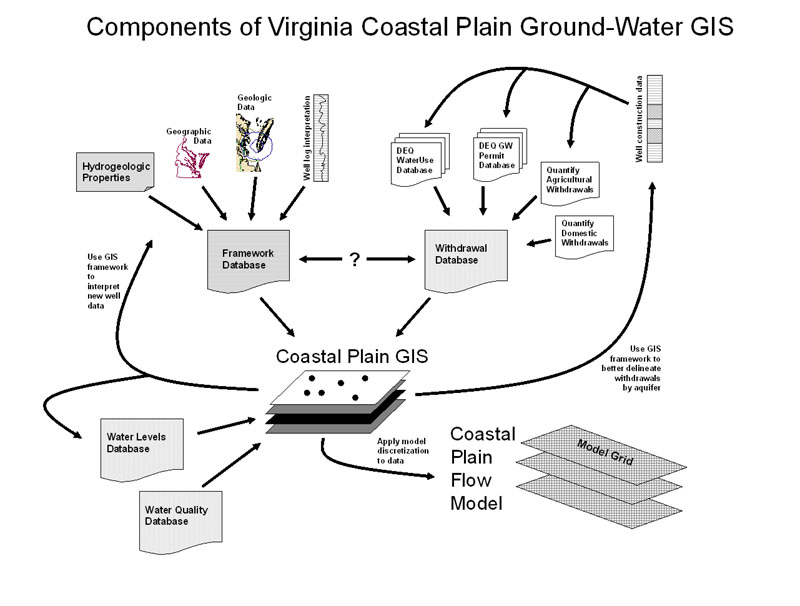
information needed for these projects requires the development and
integration of a Geographic Information System (GIS) spatial database to
facilitate data management, analysis, and visualization.
Objective
The general objective of this project is the development of a comprehensive
database to collect, catalog, analyze, and synthesize spatial and temporal data
for the Coastal Plain of Virginia and adjacent areas of Maryland and North
Carolina. Necessary components of this GIS include hydrogeologic framework unit
geometries and properties, measured and estimated ground-water withdrawals,
ground-water levels, ground-water geochemistry measurements, soil and land-cover
data, locations and characteristics of surface-water features, digital elevation
data, and population data. In addition to storing these data and allowing easy
access and revision, the GIS should also facilitate incorporation of the data
into Virginia Coastal Plain Ground-Water Model.
Relevance and Benefits
In addition to enhancing management, analysis, and visualization of data needed
for the on-going projects, a well-developed GIS for the Virginia Coastal Plain
will facilitate continual data revision and documentation, which will be
beneficial for future applications. Access to the data will also be enhanced for
cooperating public agencies. The GIS could also be further developed to allow
access, visualization, and retrieval by the public through a web portal.
Approach
Use a GIS to collect and
synthesize spatial data on all aspects of the Virginia Coastal Plain
regional aquifer system in order to 1) facilitate continual updates to the
hydrogeologic framework, 2) incorporate other spatial and temporal data such
as reported ground-water withdrawals, and 3) integrate all data into the
ground-water model. Data will be obtained from a variety of sources,
including state and local agencies, other federal agencies, and other USGS
projects and data-collection programs.
|