|
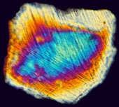
Shocked quartz thin-section
|
|
Virginia
Coastal Plain Model

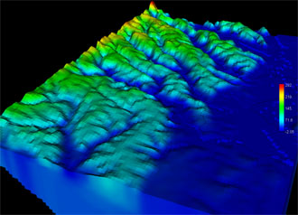 Perspective view of steady-state
ground-water distribution computed with the new Coastal Plain
Model.
Perspective view of steady-state
ground-water distribution computed with the new Coastal Plain
Model. |
Problem Large withdrawals from the multi-layer aquifer system of the Virginia Coastal Plain cause regional declines in water levels and alterations in ground-water flow. Current descriptions of the regional aquifer system are not adequate to accurately assess the effects of existing and future withdrawals.
Objective Characterize the description of the ground-water
resources in the Coastal Plain aquifers of Virginia to provide information
needed to support sound water-resource management.
Relevance and Benefits (??)(same as Jason's cp_gis.html)
In addition to enhancing management, analysis, and visualization of data needed
for the on-going projects, a well-developed GIS for the Virginia Coastal Plain
will facilitate continual data revision and documentation, which will be
beneficial for future applications. Access to the data will also be enhanced for
cooperating public agencies. The GIS could also be further developed to allow
access, visualization, and retrieval by the public through a web portal.
Approach
Collect and analyze data on poorly characterized parts of the aquifer
system, and combine with data and interpretations from other previous and
ongoing hydrologic studies, to develop an improved hydrogeologic
framework. Construct a digital numerical ground-water model that
(1) represents the improved framework,
(2) can be maintained efficiently with updated withdrawal information and other changing hydrologic conditions,
and
(3) provides information that will fulfill ongoing water-resource
management needs.
Communication Plan
A Water-Resources Investigations Report will be published to document the
revised hydrogeologic framework of the Virginia Coastal Plain. A second
Water-Resources Investigations Report will be published to document the ground-water model.
|
