USGS - science for a changing world

Virginia Water Science Center

Project Information

Title: 
Roanoke River Survey

Number: 
2482-9QE31

Location:
Roanoke River in the Cities of Salem & Roanoke, VA.

Cooperating Agencies:
U.S. Army Corps of Engineers

Project Chief:
Jennifer L. Krstolic

Period of Project:
2005 to present

USGS IN YOUR STATE

USGS Water Science Centers are located in each state.

There is a USGS Water Science Center office in each State. WashingtonOregonCaliforniaIdahoNevadaMontanaWyomingUtahColoradoArizonaNew MexicoNorth DakotaSouth DakotaNebraskaKansasOklahomaTexasMinnesotaIowaMissouriArkansasLouisiana Wisconsin IllinoisMississippiMichiganIndianaOhioKentuckyTennesseeAlabamaPennsylvaniaWest VirginiaGeorgiaFloridaCaribbeanAlaskaHawaiiNew YorkVermontNew HampshireMaineMassachusettesSouth CarolinaNorth CarolinaRhode IslandVirginiaConnecticutNew JerseyMaryland-Delaware-D.C.

Roanoke River Survey

Problem

The U.S. Army Corps of Engineers (USACE), Wilmington District and the City of Roanoke, Virginia began construction of a congressionally authorized Roanoke River Flood Reduction Project (RRFRP) in 2005. RRFRP implementation activities include: construction activities, stream bank vegetation changes, and floodplain geometry changes which are occurring in a complicated urban river system.  These activities may impact water quality, particularly sediment loading, in the vicinity of the project area, as well as downstream.  The Roanoke logperch (Percina rex), a federally listed species, is found within the project area.  Project coordination with the U.S. Fish and Wildlife Service (USFWS) in accordance with Section 7 of the Endangered Species Act (ESA) of 1973 (87 Stat. 884, as amended; 16 U.S.C. 1531 et seq.) has resulted in a specific requirement to monitor the impacts of the RRFRP on the Roanoke logperch including impacts to stream geomorphology.

The primary concerns related to stream geomorphology include sediment aggradation in Roanoke logperch habitat areas and long-term stability of the stream banks and channel.  Because of these concerns and potential impacts from implementation activities, the US Geological Survey will monitor geomorphology and channel material composition within the RRFRP and upstream of the project. 

Objectives:

1) To survey stream and floodplain cross sections to provide annual topographic data at 15 sites within the Roanoke River basin . 

  • Topographic surveys may provide information to determine whether aggredation has occurred over time.  These annual surveys may also provide information about change in stability and form of stream banks or channel. 

2) To collect substrate particle-size data at 15 sites within the Roanoke River basin .

  • Size fractions and cumulative plots may provide information to determine whether the dominant size and distribution of sediment is changing over time.  

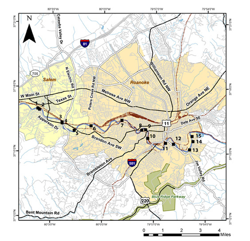
Relevance and Benefits:

Cross section surveys and substrate data collection will be done at six sites in the ‘reference reach’ upstream of the RRFRP, and at nine sites in the ‘construction reach’ of the RRFRP.  Surveys of sites within the reference reach should serve as a control for observing changes or impacts from sources upstream of the RRFRP construction area in the watershed.  All sites will be monitored for geomorphologic changes over time.  Monitoring activities should help document any impacts to the Roanoke logperch habitat throughout the project.  

Map of Study Area:

Map of study area (click to view larger map)


USGS Home Water Resources Biology Geography Geology Geospatial Program

Accessibility FOIA Privacy Policies and Notices

Take Pride in America logo USA.Gov logo U.S. Department of the Interior | U.S. Geological Survey
URL: https://va.water.usgs.gov/projects/roanoke.htm
Page Contact Information: webmaster-va@usgs.gov
Page Last Modified: 03/31/2010