
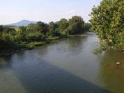
 South Fork Shenandoah River
|
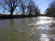
Another view of the South River.
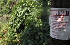 Fish Advisory: South River |
Problem
The South River and South Fork Shenandoah River are scenic recreational streams, but they are contaminated with mercury.
The mercury contamination stretches from Waynesboro for 125 miles downstream to Front Royal. A major source of the mercury
is known to be a former DuPont facility in Waynesboro that disposed mercury waste from 1929 to 1950.
Regulatory actions dealing with the streams have focused on the
health threat to people who eat mercury contaminated fish.
The VADEQ regularly samples fish to monitor concentrations of mercury in fish. In 2002, smallmouth bass had mercury concentrations as high as 4 ppm and average concentrations of 1.3 ppm. These numbers are higher than the state mandated maximum allowable mercury concentrations in fish of 0.5 ppm. Because of this, the Virginia Department of Health has placed a fish consumption advisory on the South River and South Fork Shenandoah River.
Ongoing Studies
The US Environmental Protection Agency (EPA) has
required Virginia
to develop plans for cleaning polluted streams (those on the 303d list) in
the state. This TMDL study will form the foundation used to develop a cleanup plan for the South River and
South Fork Shenandoah River.
The Virginia DEQ samples fish every year and is scheduled to do a comprehensive sediment survey in 2007.
DuPont sponsors numerous studies of the mercury problem through a group known as the South River Science Team (SRST). The South River Science Team consists of scientists and representatives from government agencies, universities, environmental non-profit groups and Dupont. The group meets regularly to share scientific findings and plan future studies. Studies currently being performed by SRST members include investigations of mercury occurrence in stream water, groundwater, surface runoff, soil, plants, fish, algae, earthworms, and birds.
In July, 2005, Dupont signed an agreement with the Natural Resources Defense Council and the Virginia Chapter of the Sierra Club that requires Dupont to perform a large six-year ecosystem study of the South River watershed. Click here for a Description of the Study (pdf file, 113 Kb) or the legal Consent Decree (pdf file, 1.1 Mb).
Objective
The objective of the South River Mercury TMDL study is to develop a better
understanding of methyl mercury cycling in the
South River
and calculate mercury loading reductions that would protect fish from high
mercury concentrations.
Approach
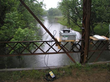
Data will be collected to calculate fluxes of mercury and methyl-mercury in
the watershed. Four monitoring stations, operated jointly by the VDEQ and the
USGS, continuously measure stream discharge and/or water quality in the South
River. These stations are at Waynesboro (01626000), South Dooms (01626850),
Dooms (01626920), and Harriston (01627500). Water samples are periodically
sampled to measure mercury and methyl-mercury concentrations along with a suite
of related water-quality parameters. The data collection will continue for 2
years.
 |
|
Continuous WQ monitoring equipment on South River bridge at Dooms, VA. |
The data will then be used to calculate mercury fluxes and to build a model of mercury cycling in the river. From this model, reductions in mercury loading required to lower fish tissue mercury concentrations to safe levels will be calculated.
 |
|
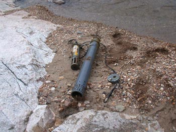
Multi-parameter WQ sensor out of the water. |
Relevance and Benefits
Work on this project will develop a foundation for the future remediation of
the South River and South Fork Shenandoah River. Basic science benefits will come
from a better understanding of methyl-mercury cycling in fresh water systems
that is developed by this project. A
better understanding of the regional aquatic ecosystem will also result from the
collection and analysis of water quality data during this project.
Presentations
Presentation to South River Science Team, June, 2005 PDF (.6 MB)
Streamflow Data
South River near Waynesboro
https://waterdata.usgs.gov/nwis/uv?site_no=01626000South River near Dooms
https://waterdata.usgs.gov/nwis/uv?site_no=01626850South River at Harriston
https://waterdata.usgs.gov/nwis/uv?site_no=01627500
Water Quality Data
South River near Waynesboro
https://waterdata.usgs.gov/nwis/uv?site_no=01626000South River near Dooms
https://waterdata.usgs.gov/nwis/uv?site_no=01626920South River at Harriston
https://waterdata.usgs.gov/nwis/uv?site_no=01627500
Links
US Geological Survey (USGS) �
USGS National Mercury Research
Active stream flow and water-quality data stations on the South River
USGS Mercury General Information
Virginia Department of Environmental Quality (VDEQ) �
South River / South Fork Shenandoah Mercury Information
TMDLs for Virginia Streams
Virginia Department of Health �
Fishing Advisories - South and South Fork Shenandoah RiverEnvironmental Protection Agency (EPA) �
Report on cleanup of former Dupont facility in Waynesboro (pdf file, 17 Kb)
Mercury Information PageSouth River Science Team (SRST) -
Conference abstract describing teamSettlement between DuPont and Natural Resources Defense Council (NRDC) �
Description of the Study (pdf file, 113 Kb)
Consent Decree (pdf file, 1.1 Mb)
Note: PDF Reader available at get.adobe.com/reader/
Site Updates
This site will be updated as new information becomes available. Suggestions and contributions welcome.