USGS visual identity
Water Resources of Virginia

Seal of the City of Virginia Beach
Project

Title
Virginia Beach Shallow Ground-Water Study

Location
Virginia Beach

Cooperating Agency
City of Virginia Beach Department of Public Utilities 

Project Chief
Jack Eggleston

Period of Project
1996 to present

Ground-water Data

Publications

Continuous records

Periodic records

Ground-Water Level and Ground-Water Quality Records, Water Year 2004 for Virginia  (PDF)


Virginia Beach Shallow Ground-Water Study
graphic element

The City of Virginia Beach 

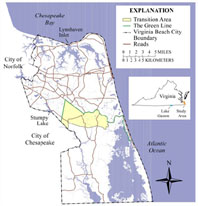
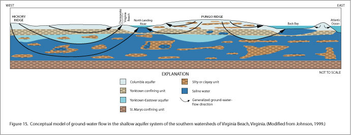
Virginia Beach is a growing city in southeastern Virginia with a limited supply of fresh water. Most of the city’s drinking water, up to 45 million gallons per day, comes from Lake Gaston. The Lake Gaston pipeline supplies water for the northern half of Virginia Beach, but the southern rural boroughs rely solely on ground water (Johnson, 1999).

Privately owned wells also provide water from shallow depths throughout Virginia Beach. The shallow wells provide water for homeowners and small to moderately sized businesses including golf courses and farms. Supplies of ground water are limited, however, because of high concentrations of iron, manganese, chloride and (or) sulfide ions in some areas. The shallow aquifers are also dewatered by several sand-and-gravel mines. At depths greater than approximately 150 to 200 ft, the water is generally
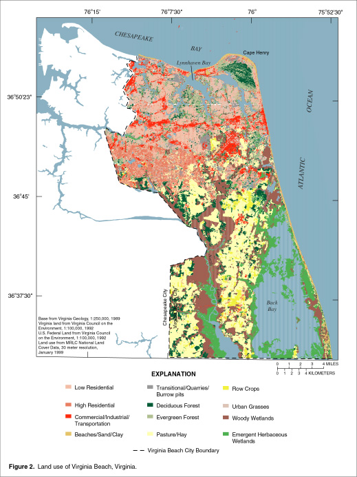
 too saline to drink.

The purpose of the Virginia Beach shallow aquifer study is to better understand the distribution of fresh ground water, its susceptibility to contamination, and its sustainability as a long-term water supply.

The city of Virginia Beach has an interest in preserving the limited supply of water in the shallow aquifers for drinking, irrigation, lawn watering, heat pumps, and potentially for desalination. The U.S. Geological Survey (USGS), in cooperation with the City of Virginia Beach Department of Public Utilities, began a cooperative study of the shallow aquifer system in 1996. 

Shallow quifer system schematic

Virginia Beach landuse map/pop-up

Virginia Beach land use

During this study,  the USGS has collected continuous cores and geophysical logs from the shallow aquifer system  and revised the conceptual hydrogeologic framework of the system (Smith and Harlow, 2002). A water-level and water-quality network has been established in the city and continuous water-level records have been collected for several wells.

The USGS also simulated ground-water flow and the distribution of saline water, as indicated by chloride concentration, in the shallow aquifers of the southern watersheds of Virginia Beach (Smith, 2003). Slow, but steady movement of chloride concentrations toward a hypothetical well field pumping from the York-Eastover aquifer was simulated, as well as, drawdowns around hypothetical open-pit mines in the Columbia aquifer.

In 2004, the USGS and the Virginia Department of Public Utilities expanded the observation-well network and simulated ground-water pumping from the shallow aquifers in the Transition Area.

In 2005, more continuous-record wells including "real-time" water-level monitors were added to the network. Also, a  USGS Scientific Investigations Report on the results of the  ground-water flow simulations for the shallow aquifers was published in the summer of 2005.

Figure 15 from SIR-05-5067

Figure 15 from SIR 2005-5067


Publications:

1. Virginia Beach Shallow Ground-Water Study USGS Fact Sheet (Johnson, 1999)

2. Conceptual Hydrogeologic Framework of the Shallow Aquifer System at Virginia Beach, Virginia (Smith & Harlow, 2001) WRIR 01-4262

3. Ground-Water Flow and Saline Water in the Shallow Aquifer System of the Southern Watersheds of Virginia Beach, Virginia (Smith, 2003) WRIR 03-4258

4. Simulated Changes in Water Levels Caused by Potential Changes in Pumping from Shallow Aquifers of Virginia Beach, Virginia (Smith, 2005) SIR 2005-5067


Weather data for Virginia Beach area
Virginia Projects or: Water Resources of Virginia
Contact: GS-W-VArmd_webmaster@usgs.gov
U.S. Department of Interior, U.S. Geological Survey
Privacy Statement

Disclaimer
Accessibility
URL: http://va.water.usgs.gov/projects/va113.html
 
Last modified: Friday, September 08, 2006 10:34:18 AM