|
|
Chesapeake Bay Impact
Structure
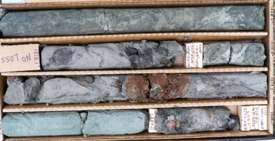
Problem: Recently, geologists of the USGS and the Virginia Department of Environmental Quality have discovered the existence of a 90 km diameter, 1.7 to 2.0 km deep impact crater beneath the lower Chesapeake Bay region. The present geological framework used by hydrologists for ground-water-flow modeling and aquifer systems analysis in the area predates the discovery of this impact crater. Formation of this crater probably altered the hydraulic properties of the sediments within and adjacent to the crater and may have introduced salty water in the aquifers further inland. Objective: Refine the geology of the Cretaceous and Tertiary sediments of the York-James Peninsula in and near the impact crater. Refinement of the geohydrologic framework will take considerable skill and time but a first step towards that refinement will be the revision of the geology in this region. Relevance and Benefits: The study will provide valuable information for advancing the knowledge of the regional Coastal Plain aquifer system in Virginia in an area that has been affected by a 35 million year old meteor impact. This information is of deep interest to State and local agencies tasked with the development and management of the State's water resources.
Approach: Re-evaluate
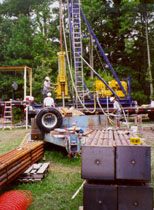
borehole geophysical logs used previously in the Coastal Plain RASA, as well as
more recently derived borehole logs from wells drilled on the York-James
Peninsula. The data will be
synthesized and used to construct cross sections and maps of the geology so that
subsequent work can begin to refine the geohydrologic framework.
|
| Virginia Projects or: Water Resources of Virginia |
| Contact: GS-W-VArmd_webmaster@usgs.gov |
| U.S. Department
of Interior, U.S. Geological Survey Privacy Statement Disclaimer Accessibility |
| URL: http://va.water.usgs.gov/projects/va120.html |