|
| Project |
|
Title
Joint Development of USGS/CBP Watershed Model
Numbers
2482-9RQE20, 2482-9RQE21, 2427-B4I00
Location
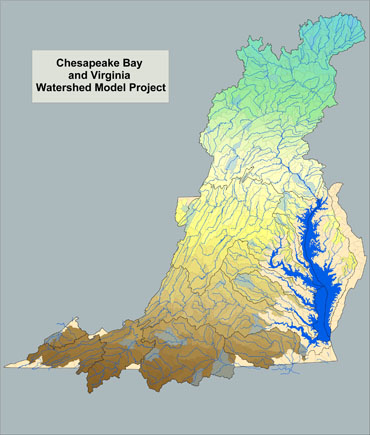
Chesapeake Bay watershed
Cooperating Agencies
Interstate Commission of the Potomac River Basin, Virginia
Department of Conservation and Recreation
Principal Investigators
Doug Moyer
Jeff Raffensperger
Period of Project
July 1, 2001 to September 30, 2005
|
|
|
|
Joint Development of USGS/CBP Watershed Model

Problem
Elevated nutrient and suspended solid levels in the Chesapeake
Bay adversely affect water clarity and DO levels, stressing living resources in the Bay
and its tributaries. In 1987, the Chesapeake Bay Agreement called for 40% reduction in
controllable nutrients entering the Bay by the year 2000. In 2000, a renewed Chesapeake
Bay agreement was created to reinforce and redefine efforts toward these nutrient
reductions. In an effort to reduce nutrients and sediments entering the Bay, management
strategies have been implemented in the tributary basins. Quantification of loads and
trends is useful for assessing the success of these management practices in improving
water quality and living resource response.
Objectives
The USGS is collaborating with the Chesapeake Bay Program (CBP) to
incorporate the USGS Potomac Watershed and Chesapeake Bay Virginia Watershed models into Phase 5 of the Chesapeake Bay Watershed Model (CBWM). This effort
includes the following objectives:
- Compile necessary spatial and temporal databases for simulation of
Chesapeake Bay watershed processes (hydrological, nutrient cycling,
and sediment transport) using HSPF, in cooperation with ICPRB and CBP
staff.
- Create watershed segmentation, river reach segmentation, and
associated control files for HSPF simulation of the Chesapeake Bay
Watershed.
- Develop and implement innovative calibration procedures, such as
inverse modeling and analysis of scaled model sensitivities, to
improve HSPF model calibration and provide additional insight into
important controls on nutrient and sediment transport and processing
within the Chesapeake Bay Watershed.
- Calibrate an HSPF model for the Chesapeake Bay Watershed, in
collaboration with CBP.
- Prepare reports on subjects that might include (but are not limited
to) the following: calibration of the CBWM; analysis of calibration
strategies; CBWM uncertainty; analysis of CBWM results; implications
for present and future monitoring and other data collection
activities.
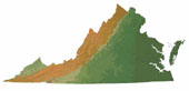
- As an additional objective, the CBWM will be expanded in Virginia to
include the parts of the state outside the Chesapeake Bay Watershed.
Approach
The study involves the following tasks:
- Data Compilation: compilation of existing input data (e.g., land use/cover, sources of N
and P, and meteorological data; development of model segmentation, model network, and
construction of UCI (User's Control Input) files; processing of time-series data to create
input WDM (Watershed Data Management) files; compilation of ancillary data and observational data (for model calibration).
- Development of Model Calibration Strategy: implementation of existing software for
general inversion and calibration of multi-parameter hydrological models.
- Model Calibration: calibration of hydrological model; calibration of water- quality model
(suspended sediment and nutrients, N and P, and their speciation).
- Analysis of Model Results: results of model calibration, examination of model output,
and consideration of specific study questions.
- Delivery of Results and Final Reports: dissemination of data sets and model input and
output files and preparation of final reports analyzing the model results.
Relevance and Benefits
Federal, State, and Local governments need tools to evaluate alternative approaches for correcting existing
water-quality and water- quantity problems
and for forecasting future conditions within the Chesapeake Bay Watershed. The development and calibration of an HSPF model of the watershed will provide insight into
processes controlling the processing of nutrients and sediment within the watershed. The
calibrated watershed will allow resource managers to simulate large-scale effects of land-use changes and best management practices on water-quality. Critical areas needing
nonpoint-pollution control measures can be identified, and benefits to be gained by
various management strategies can be evaluated.
The study meets several goals of the Water Resources Discipline (WRD) of the USGS,
by:
1) advancing knowledge of the regional hydrological system;
2) advancing understanding of hydrological processes; and
3) providing water-resources information that will be used by multiple parties for planning and operational purposes.
In addition, the proposed study will benefit ongoing PODL (Potomac-Delmarva Subunit) NAWQA
studies that address questions related to fate and transport of agrochemicals, nutrient
enrichment, and nutrient processing within the watersheds and stream.
|