Virginia Water Science Center
|
DATA CENTER
|
Water Resources of Warren County, VirginiaThe Northern Shenandoah Valley is underlain by karst and fractured-rock aquifers that are increasingly being relied upon to supply water to local communities and individual residences. This is an area with an expanding economy and a growing population, and, to meet future water needs, these aquifers are likely to be developed to supplement current withdrawals. The recent prolonged drought (1998-2002) and increasing development has focused attention in Warren County, Virginia on the quantity and sustainability of the ground-water resources. An improved understanding of these complex aquifer systems is required to effectively develop and manage them as sustainable water supplies. In order to assess current and future hydrologic conditions within the County, a detailed aquifer appraisal is being conducted to provide hydrogeologic information to better address questions about (1) the quantity of water available for use, (2) the effects of increased pumpage on ground-water levels and instream flows, and (3) the quality of the ground-water supply and its vulnerability to current and potential future sources of contamination. An initial phase of a long-term monitoring network has been implemented. Hydrogeologic Setting and Project Background
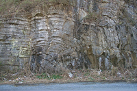
The area considered in this study is underlain by complexly folded and faulted carbonate, siliciclastic, and crystalline rocks of Warren County, Va. The establishment of a long-term data network and further evaluation of information from previous studies was part of this hydrogeologic assessment, and will aid future land-use and water-supply planning activities in the County. For information, contact David Nelms at dlnelms@usgs.gov Warren County Water-Monitoring NetworksThe Virginia Water Science Center, in cooperation with Warren County, maintains a network of water-monitoring stations measuring many aspects of surface and ground water, along with water-quality parameters.
Current Water Conditions for Warren Co.
Current Water Conditions for the Shenandoah Valley
|

![]() U.S. Department of the Interior
| U.S. Geological Survey
U.S. Department of the Interior
| U.S. Geological Survey
URL: http://va.water.usgs.gov/warren/index.html
Page Contact Information: webmaster-va@usgs.gov
Page Last Modified: 18-Aug-2008 11:00:00 EDT