USGS - science for a changing world

Virginia Water Science Center

Warren County Web site.

Search this site:

DATA CENTER

  • USGS IN YOUR STATE

    USGS Water Science Centers are located in each state.

    There is a USGS Water Science Center office in each State. Washington Oregon California Idaho Nevada Montana Wyoming Utah Colorado Arizona New Mexico North Dakota South Dakota Nebraska Kansas Oklahoma Texas Minnesota Iowa Missouri Arkansas Louisiana Wisconsin Illinois Mississippi Michigan Indiana Ohio Kentucky Tennessee Alabama Pennsylvania West Virginia Georgia Florida Caribbean Alaska Hawaii New York Vermont New Hampshire Maine Massachusettes South Carolina North Carolina Rhode Island Virginia Connecticut New Jersey Maryland-Delaware-D.C.

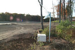
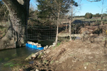
Water-Monitoring Networks for Warren County, Virginia

The water-monitoring networks for Warren County, Va. consist of real-time and quarterly measurements.  Real-time data are collected every 15 minutes and transmitted either by satellite or telephone every 1 or 3 hours, respectively.  Quarterly data are collected in January, April, July, and October.

Real-Time Water-Monitoring Networks


Well 45V  3 Streamflow, ground-water levels, and water quality (specific conductance and water temperature) are collected every 15 minutes at 8 sites throughout the county.

     Daily and statistical data


Quarterly Water-Monitoring Networks


Spring 45VS  1

Spring discharges and field water-quality properties (pH, specific conductance, temperature, and dissolved oxygen) are measured in 2 springs to document seasonal changes in flow and water quality.  Continuous gage height records are also collected in these 2 springs to document flow conditions between quarterly spring discharge runs.  Beginning in Fiscal Year 2009, water levels in up to 40 wells will be measured quarterly to document seasonal ground-water changes and current hydrologic conditions.

     Quarterly and statistical data


Current Water Conditions for Warren Co.

Shaded relief map of Warren County, Va.The USGS and Virginia Department of Environmental Quality provide current ("real-time") stream stage and streamflow, water-quality, and ground-water levels for 8 sites in Warren County, Va.

Current Water Conditions for the Shenandoah Valley

Shaded relief map of the Shenandoah Valley of Virginia and West VirginiaThe USGS and Virginia Department of Environmental Quality provide current ("real-time") stream stage and streamflow, water-quality, and ground-water levels for 35 sites in the Shenandoah Valley of Virginia and West Virginia.

USGS Home Water Resources Biology Geography Geology Geospatial

Accessibility FOIA Privacy Policies and Notices

Take Pride in America logo FirstGov logo U.S. Department of the Interior | U.S. Geological Survey
URL: http://va.water.usgs.gov/warren/netw.htm
Page Contact Information: webmaster-va@usgs.gov
Page Last Modified: 18-Aug-2008 11:00:00 EDT