|

DATA CENTER
USGS IN YOUR STATE
USGS Water Science Centers are located in each state.
 |
VDMR Geographic Information System (GIS) Data for Warren County, Virginia
Geographic information system (GIS) data consists of map layers that are
being used to evaluate the
relations between the hydrogeology, geologic structures, and topography
|
|
|
 |
Virginia Division of Mineral Resources (VDMR)
( )
-- VDMR has digital representations and printed geologic maps
available online at the Virginia Department of Mines, Minerals
and Energy (DMME) Web Store. )
-- VDMR has digital representations and printed geologic maps
available online at the Virginia Department of Mines, Minerals
and Energy (DMME) Web Store.
|
| |
|
|
|
|
|
| |
 |
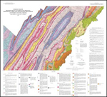
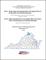
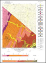
 Publication 102: Geologic Map of Warren County,
Virginia and Map of Selected Hydrogeologic Components
for Warren County, Virginia
Publication 102: Geologic Map of Warren County,
Virginia and Map of Selected Hydrogeologic Components
for Warren County, Virginia |
|
|
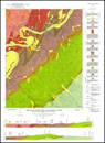
Publication 143: Geologic Map of Clarke,
Frederick, Page, Shenandoah, and Warren Counties,
Virginia: Lord Fairfax Planning District |
| |
|
|
|
|
|
| |
 |
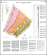
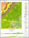
Publication 161: Geologic Map of the Virginia
Portion of the Winchester 30 X 60-minute Quadrangle |
|

|
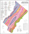
Publication 162: Geologic Map of the Front Royal
30 x 60-minute Quadrangle: Portions of Clarke, Page,
Rockingham, Shenandoah, and Warren Counties, Virginia |
| |
|
|
|
|
|
| |
 |
Publication 171: Digital Representation of the
Geologic Map of the Virginia Portion of the Winchester
30x60-minute Quadrangle |
|
 |
Report of Investigations 034: Geology of the
Berryville, Stephenson, and Boyce Quadrangles, Virginia |
| |
|
|
|
|
|
| |
 |
Report of Investigations 036: Geology of the
Ashby Gap Quadrangle, Virginia |
|
 |
Report of Investigations 044: Geology of the
Linden and Flint Hill Quadrangles, Virginia with a
Section on Hydrogeology by R.H. DeKay |
| |
|
|
|
|
|
|


