|

DATA CENTER
USGS IN YOUR STATE
USGS Water Science Centers are located in each state.
 |
Additional Water-Resources Data for Clarke County, Virginia
In addition to the water-monitoring networks for Clarke County, Va.,
data are being collected as part of the hydrogeologic assessment of the
water resources.
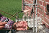 |
Age dating ( )--
Various dating techniques were used to determine the apparent
age of ground water discharging from 15 springs in the County.
Ground water recharged within the past 60 years can be dated
using chlorofluorocarbons (CFCs, Freon), sulfur hexafluoride
(SF6), and tritium (3H)/helium (3He). )--
Various dating techniques were used to determine the apparent
age of ground water discharging from 15 springs in the County.
Ground water recharged within the past 60 years can be dated
using chlorofluorocarbons (CFCs, Freon), sulfur hexafluoride
(SF6), and tritium (3H)/helium (3He).
|
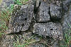 |
Geology
()
-- Knowledge of the geology is a critical component in
understanding the ground-water flow systems in the
County. Rock type and geologic structure act as
controls on ground-water flow and occurrence of springs.
|
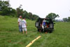 |
Geophysics
()
-- Various borehole and surface geophysical methods are
being used to identify the nature of fracturing, karst
features, depth to bedrock, and ground-water/surface-water
interactions.
|
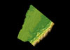 |
GIS
()
--
Geographic information system (GIS) data are being used to evaluate the
relations between the hydrogeology, geologic structures, and topography.
|
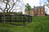 |
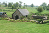
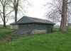
Photo
Gallery ()
--
Digital photographs are being used to document well and spring
locations, hydrogeologic settings, and geologic features.
|
 |
Water
quality ()
-- Various types of water-quality data collected by the U.S.
Geological Survey are available for springs, streams, and wells
in the County.
|
 |
Water
use ()
-- The U.S. Geological Survey compiles and publishes
water-use data for the United States every 5 years.
Water-use data are available for
other
counties in Virginia.
|
|


