|

DATA CENTER
USGS IN YOUR STATE
USGS Water Science Centers are located in each state.
 |
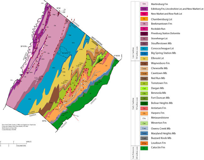
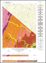
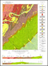
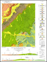
Geology Data for Clarke County, Virginia
Geology data data consists of rock type, formations, geologic
structures, and sinkholes
|
| Geology
compiled from: |
 USGS Open-File Report 01-227: Geologic Map Database of
the Washington DC Area Featuring Data from Three 30 x 60
Minute Quadrangles: Frederick, Washington West, and
Fredericksburg
USGS Open-File Report 01-227: Geologic Map Database of
the Washington DC Area Featuring Data from Three 30 x 60
Minute Quadrangles: Frederick, Washington West, and
Fredericksburg
VDMR Publication 162: Geologic Map of the Front Royal
30 x 60-minute Quadrangle: Portions of Clarke, Page,
Rockingham, Shenandoah, and Warren Counties, Virginia
VDMR Publication 171: Digital Representation of the
Geologic Map of the Virginia Portion of the Winchester
30x60-minute Quadrangle
|
|
| |
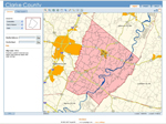 |
Clarke
County Web-Based Map Viewer ( )--
The County's GIS map layers are available online through
interactive map viewer. The map layers available are: )--
The County's GIS map layers are available online through
interactive map viewer. The map layers available are:
| |
|
|
|
|
Aerial Photos |
Sinkholes |
Soils |
|
|
|
|
|
 |
Virginia Division of Mineral Resources (VDMR)
()
-- VDMR has digital representations and printed geologic maps
available online at the Virginia Department of Mines, Minerals
and Energy (DMME) Web Store.
|
| |
|
|
|
|
|
| |
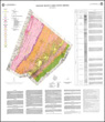 |
Publication 102: Geologic Map of Clarke County,
Virginia and Map of Selected Hydrogeologic Components
for Clarke County, Virginia |
|
|
Publication 143: Geologic Map of Clarke,
Frederick, Page, Shenandoah, and Warren Counties,
Virginia: Lord Fairfax Planning District |
| |
|
|
|
|
|
| |
 |
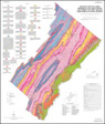
Publication 161: Geologic Map of the Virginia
Portion of the Winchester 30 X 60-minute Quadrangle |
|

|
Publication 162: Geologic Map of the Front Royal
30 x 60-minute Quadrangle: Portions of Clarke, Page,
Rockingham, Shenandoah, and Warren Counties, Virginia |
| |
|
|
|
|
|
| |
 |
Publication 171: Digital Representation of the
Geologic Map of the Virginia Portion of the Winchester
30x60-minute Quadrangle |
|
 |
Report of Investigations 034: Geology of the
Berryville, Stephenson, and Boyce Quadrangles, Virginia |
| |
|
|
|
|
|
| |
 |
Report of Investigations 036: Geology of the
Ashby Gap Quadrangle, Virginia |
|
 |
Report of Investigations 044: Geology of the
Linden and Flint Hill Quadrangles, Virginia with a
Section on Hydrogeology by R.H. DeKay |
| |
|
|
|
|
|
|
|
|
 |
U.S.
Geological Survey (USGS)
()
-- USGS has digital representations of the geology,
topography, and hydrology of the County.
| Geology |
|
 |
Open-File Report 01-227: Geologic Map Database of
the Washington DC Area Featuring Data from Three 30 x 60
Minute Quadrangles: Frederick, Washington West, and
Fredericksburg
|
 |
Open-File Report 2006-1173: Geologic Map of the
Stephens City Quadrangle, Clarke, Frederick, and Warren
Counties, Virginia
|
 |
Sinkholes: Shapefile digitized from
VDMR Publication 102: Geologic Map of Clarke County,
Virginia and Map of Selected Hydrogeologic Components
for Clarke County, Virginia |
 |
Sinkholes: Shapefile of potential sinkholes on
USGS 7.5-minute quadrangles: |
- Boyce, VA.
- Capon Bridge, WV- VA
- Capon Springs, WV-VA
- Glengary, WV-VA
- Gore, VA
|
- Hayfield, VA
- Inwood, VA
- Middletown, VA
- Mountain Falls, VA-WV
- Ridge, WV-VA
|
- Stephens City, VA
- Stephenson, VA-WV
- Wardensville, WV-VA
- White Hall, VA-WV
- Winchester, VA
|
 |
Lineaments: Shapefile digitized from
VDMR Publication 102: Geologic Map of Clarke County,
Virginia and Map of Selected Hydrogeologic Components
for Clarke County, Virginia
|
|
|


