|

DATA CENTER
USGS IN YOUR STATE
USGS Water Science Centers are located in each state.
 |
USGS Geographic Information System (GIS) Data for Clarke County, Virginia
Geographic information system (GIS) data consists of map layers that are
being used to evaluate the
relations between the hydrogeology, geologic structures, and topography
|
|
|
 |
U.S.
Geological Survey (USGS)
( )
-- USGS has digital representations of the geology,
topography, and hydrology of the County. )
-- USGS has digital representations of the geology,
topography, and hydrology of the County.
| Geology |
|
 |
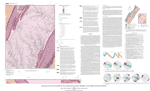
 Open-File Report 01-227: Geologic Map Database of
the Washington DC Area Featuring Data from Three 30 x 60
Minute Quadrangles: Frederick, Washington West, and
Fredericksburg
Open-File Report 01-227: Geologic Map Database of
the Washington DC Area Featuring Data from Three 30 x 60
Minute Quadrangles: Frederick, Washington West, and
Fredericksburg
|
 |
Open-File Report 2006-1173: Geologic Map of the
Stephens City Quadrangle, Clarke, Frederick, and Warren
Counties, Virginia
|
 |
Sinkholes: Shapefile digitized from
VDMR Publication 102: Geologic Map of Clarke County,
Virginia and Map of Selected Hydrogeologic Components
for Clarke County, Virginia |
 |
Sinkholes: Shapefile of potential sinkholes on
USGS 7.5-minute quadrangles: |
- Boyce, VA.
- Capon Bridge, WV- VA
- Capon Springs, WV-VA
- Glengary, WV-VA
- Gore, VA
|
- Hayfield, VA
- Inwood, VA
- Middletown, VA
- Mountain Falls, VA-WV
- Ridge, WV-VA
|
- Stephens City, VA
- Stephenson, VA-WV
- Wardensville, WV-VA
- White Hall, VA-WV
- Winchester, VA
|
 |
Lineaments: Shapefile digitized from
VDMR Publication 102: Geologic Map of Clarke County,
Virginia and Map of Selected Hydrogeologic Components
for Clarke County, Virginia
|
| |
|
| Topography |
|
 |
30-meter Digital Elevation Models (DEM)
|
 |
30-meter DEM Hillshade
|
 |
10-meter National Elevation Dataset (NED) Digital
Elevation Models (DEM)
|
 |
10-meter NED-DEM Hillshade
|
 |
Slope: Slope derived from 30-meter DEM. |
|
|
|
|
|
|
| Hydrology |
|
 |
Water-Monitoring Network Sites: Shapefile of
wells, springs, and streamflow gages in the Clarke
County water-monitoring networks |
 |
Springs: Shapefile of spring locations |
 |
Age-Dating Sites: Shapefile of springs sampled
for ground-water age dating |
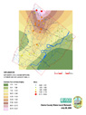 |
Water-Level Net Change: Raster of kriged
water-level net change after the drought of 1998-2002 |
|
Dry Stream Segments: Shapefile of dry stream
segments at the end of the drought of 1998-2002 |
|
|
|
|
|
|
|
|


