|


Cooperating Agencies
|
|
Virginia
Coastal
Plain Aquifer System Analysis

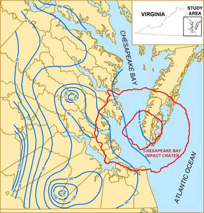 Groundwater Levels (in feet) in the Virginia
Coastal Plain
Groundwater Levels (in feet) in the Virginia
Coastal Plain
|
Problem
Groundwater
is a heavily used source of water in the Virginia Coastal Plain. Long term and
widespread groundwater withdrawals have resulted in regional water-level
declines, and created the potential for saltwater intrusion. Sound management of
this vital resource relies on continual improvement of the scientific
understanding of the aquifer system.
Objective
To gain
knowledge of hydrogeologic conditions and processes in the Virginia Coastal
Plain that will facilitate sound water-resource management.
Relevance and Benefits
Knowledge is
advanced of the regionally extensive groundwater system of the Coastal Plain of
Virginia and adjacent states. Ongoing needs are addressed for understanding
changing groundwater conditions and associated hydrologic processes of this
increasingly developed, multi-state water resource. Hydrologic data and
information are critical to insuring sound management and continued viability of
a major water supply to millions of citizens.
Approach
Collect and analyze data on poorly known aspects of the Virginia Coastal
Plain aquifer system, and combine with results from other previous and ongoing
studies, to develop improved understandings of hydrogeologic conditions,
groundwater flow, and chemical quality. Interpret and present results to fulfill
ongoing water-resource management needs.
Project Background
The Atlantic Coastal Plain spans nearly the entire U.S. east coast, and in
Virginia occupies an area of 13,000 square miles. The Coastal Plain is underlain
by a wedge of regionally extensive, eastward dipping strata of generally
unconsolidated sediments, most of which were deposited over basement bedrock by
streams and deltas during the Cretaceous Period, and by the Atlantic Ocean
during the Tertiary Period. Also during the Tertiary Period, impact of an
asteroid or comet created a 50-mile wide crater containing a unique assemblage
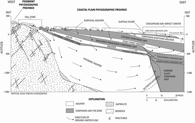
of materials, now buried 1,000 feet below the surface.
Virginia Coastal Plain sediments form a series of hydrogeologic units. Permeable
sediments through which most groundwater flows are designated as aquifers, and
less permeable sediments that restrict flow are designated as confining units or
zones. The aquifers have been a heavily and increasingly used water resource in
Virginia for many decades, with a current withdrawal rate of nearly 140 million
gallons per day. As a result, groundwater levels have declined by as much as 200
feet, and flow gradients have been altered to create the potential for saltwater
intrusion.
In order to manage the groundwater resource, State and local agencies have
maintained a sound scientific understanding of Virginia Coastal Plain
hydrogeology through a cooperative program of investigation with the U.S.
Geological Survey (USGS). A hydrogeologic framework and computer model of the
aquifer system developed by the USGS during the 1980s was adapted by the
agencies to evaluate the potential effects of existing and proposed withdrawals.
With discovery of the Chesapeake Bay impact crater and other newly emerged
geologic relations, and further stress on the flow system imposed by ongoing
groundwater withdrawal, a revised hydrogeologic framework and two computer
models have since been developed to provide resource-management efforts with a
contemporary analysis of groundwater conditions. In addition, the chemical
quality of groundwater in the Virginia Coastal Plain has been described based
on the revised hydrogeologic framework.
Currently, other poorly known aspects of the aquifer system are being investigated
that pose significant implications for continuance of the water supply. All results
are tailored toward meeting the ongoing needs of water-resource management.
Virginia Coastal Plain Aquifer System
|