USGS - science for a changing world

Virginia Water Science Center

Warren County Web site.

Search this site:

DATA CENTER

  • USGS IN YOUR STATE

    USGS Water Science Centers are located in each state.

    There is a USGS Water Science Center office in each State. Washington Oregon California Idaho Nevada Montana Wyoming Utah Colorado Arizona New Mexico North Dakota South Dakota Nebraska Kansas Oklahoma Texas Minnesota Iowa Missouri Arkansas Louisiana Wisconsin Illinois Mississippi Michigan Indiana Ohio Kentucky Tennessee Alabama Pennsylvania West Virginia Georgia Florida Caribbean Alaska Hawaii New York Vermont New Hampshire Maine Massachusettes South Carolina North Carolina Rhode Island Virginia Connecticut New Jersey Maryland-Delaware-D.C.

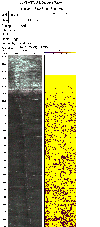
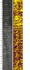
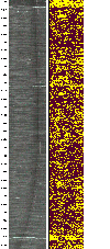
Geophysical Data for Warren County, Virginia--Borehole logging


Below are optical (left) and acoustic (right) televiewer logs for well 45V  4.  Click on images for larger views.
     

Top
 

Middle
 

Bottom
 

Go to top section of televiewer images for well 45V  4


Go to middle section of televiewer images for well 45V  4

Go to bottom section of televiewer images for well 45V  4
   

Navigate to:
 

Surface Geophysics
Go To Warren Co. Geophysical data--Optical televiewer image from well 45V  4 Warren County Geophysical data
 

Additional information on geophysical techniques used in hydrologic investigations is available at the U.S. Geological Survey, Office of Ground Water, Branch of Geophysics (http://water.usgs.gov/ogw/bgas/))


Current Water Conditions for Warren Co.

Shaded relief map of Warren County, Va.The USGS and Virginia Department of Environmental Quality provide current ("real-time") stream stage and streamflow, water-quality, and ground-water levels for 8 sites in Warren County, Va.

Current Water Conditions for the Shenandoah Valley

Shaded relief map of the Shenandoah Valley of Virginia and West VirginiaThe USGS and Virginia Department of Environmental Quality provide current ("real-time") stream stage and streamflow, water-quality, and ground-water levels for 35 sites in the Shenandoah Valley of Virginia and West Virginia.

USGS Home Water Resources Biology Geography Geology Geospatial

Accessibility FOIA Privacy Policies and Notices

Take Pride in America logo FirstGov logo U.S. Department of the Interior | U.S. Geological Survey
URL: http://va.water.usgs.gov/warren/geoph.htm
Page Contact Information: webmaster-va@usgs.gov
Page Last Modified: 18-Aug-2008 11:00:00 EDT